It was a beautiful drive from Casper, through the Continental Divide, to Rock Springs. Our new temporary home was right off I-80. You ask, how did Rock Springs get its name? It is said that while mining, they broke rock and out sprung water. Is it true, I don't know.
The Rock Springs National Forest was actually our site's outdoor space. We were fortunate to be pointing toward the hills, that way we could sit in the shade of our RV, and enjoy the hills. We took a walk around the park just to see the make-up of this campground. The tent camping area is set up so that each tent has privacy.
The cabins are located together but have enough separation for intimate conversations. The larger cabins can sleep up to seven people, and the smaller cabins towards the back can sleep four people.And the rest of the campground is for us monster rigs. The sites with fencing are the fancy ones that provide a bit more privacy, concrete patio, grass, and some have a portico on them.
One day I took a walk in the hills behind the campground, and had a great time. Part of the land is privately owned, the rest is owned by the government. The land owner has given the campground permission to access his land. It is said that there are shell fossils on the government land, so I figured I try to find something.
On my journey I came across a cave that may have been used as an entrance to a mine. Today the cave is filled with water, possibly from an underground stream. Above the cave there is a dry stream bed, which fills after the snow season.
I continued on through the countryside, and I think I found a few plant fossils, not really sure though.
Our ventures started downtown at the old City Hall. The old City Hall contained the police station with jail, fire station, judge's chambers and courtroom, and municipal offices, and is handicap friendly. The museum is free, donations are appreciated; you can visit them at: rswy.net.
Old City Hall
Walking into the building, and to the right was the police station and jail.
The original police station was larger during it's active days up to 1983, during the 1992 restoration, a portion was utilized for the new bookstore and restrooms. The jail was downstairs in the beginning, and was one cell that held 10 people. Access to the single cell was through the stable downstairs. After the new jail was completed it was moved upstairs and had six cells. For the person that was of questionable mental state there was a special cell for them, padded walls and floor. The original floor in the padded cell was made of oil cloth and horse hair, which was removed during the 1992 restoration because it was so deteriorated. The new cells had a shower in them, with the water temperature controlled from outside the cell.
One major difference with the padded cell was the fact that there was no shower available, simply because it was only meant for temporary detainment.
Strolling farther down the hall and down a set of stairs, you arrive at the fire station (originally the fire station could not be accessed through the main building). The Fire Department got it's start as "Clark Hose Company #1", thanks to a generous donation of 500 feet of hose and a hand drawn hose reel by Mr. D.O. Clark. The problem with responding to fires in the beginning was caused from a whistle located at Mine #, which did not provide indication of where the fire was.
To improve response times, fire boxes were installed at the street and an annunciating system in the station. Some of the original equipment was still present. The fire alarm equipment was the most enjoyable for me because of my days working with fire alarms in the civilian sector, and the government. The system they used at this station even pre-dated some of the systems I worked on.

The way the system worked "back in the day" was an alarm was pulled at a box at the street. The assigned box number would cause the associated cog to operate in the annunciator. Notice the teeth on each cog. As the arm moved from the "rest" position, which represented "1", then a break, and more teeth, each tooth representing a number (i.e. 34: "rest" space + 2 teeth, break, 4 teeth). "34" indicates an alarm at East Flat.
What fire station can function without the boss' office... this place was no different.
If you look really close you can see their computer... oh wait, that's a typewriter and a log book. You say you want to see how they kept their records and stats, I think I can help with that:
Think of these as Word and Excel documents. So when you have a small bump in the road on your computer, be happy you don't have to rewrite an entire log book.
Upstairs was a phenomenal walk through time. A lot of nationalities were represented, many brought over by Union Pacific Railroad to work the mines and railroad they owned.
Union Pacific was pleasantly surprised they had a hard time depleting the coal supply in the area. The map above indicates the coal richness in the area. Coal mining technics changed over the last 150 years. In the early days there wasn't much safety concern when it came to mining, but due to the increase in deaths, safety processes were created. The museum exhibit is astonishing.
The Mc Caa (pronounced Mc Cay) Apparatus was a device designed to supply two hours of oxygen during mine rescue operations.
Gas Mask
First Aid Kit
The mining world moved from candle head lamps to electric head lamps. The electric head lamps required batteries to operate. Well, to keep the batteries charged, someone made a battery charger for the worker's batteries.
Rock Springs was a coal and train town... it was a Union Pacific town. A bit of coal mining still goes on here.
History fact:
One day in 1885 there was confusion as to who was working in one of the "rooms" in the mine. White European workers went to lunch, Chinese workers who were also assigned that particular room came in to work. The White workers came back from lunch and found the Chinese men working their coal. A confrontation broke out, and other white workers got involved, so the mine was shut down for that day. Well, that was not enough damage caused by the white workers, a mob of about 150 attacked the Chinese workers in their homes. All said and done, 28 Chinese men had been killed.
Let's jump to the future, say early 1900's. The immigrants usually brought with them their wine, alcohol, beer skills. Besides making wine, Italians loved to drink their product at meals. The Greeks loved their ouzo whenever they could. Then you had us "Americans" and their moonshine.
Moving smartly into 1919, law was passed prohibiting the making, selling, distribution of alcohol. The period lasted from January 1920 to December 1933, but people still wanted their alcohol. Bar owners had unique ways of disposing of the contraband liquor. The owner of the Fountain Club stored his bourbon in a copper container with a plug in the bottom, so that when federal agents raided the bar, the bartender could drain the evidence. Another method to beat the Feds was accomplished by one bar called ahead to another bar, giving a heads up. One consumer made comment that there was no prohibition, it was free as ever.
Today we have gone soft. Put yourself around 1916 and a tooth in your head has gone rogue, causing so much pain that a dentist is needed. While waiting to see the dentist you doze off and start dreaming about being in a comfortable padded dentist chair, with soft soothing music playing, and just before the "laughing gas" kicks in... you are brought back to 1916 in a musty smelling dentist office waiting room and the sweet assistant yells your name three times. As she escorts you into the exam room she tells you to sit in the comfortable dental chair... not, you actually are seated in this:
That's right, metal seat with wooden back rest. That rogue tooth needs pulling, which could be quite painful as well, the dentist doesn't have the choice of "laughing gas". You still with me?
Technology was on the move in the early 1900s, and if one was lucky enough, they could experience this new technology. The technology I am talking about... the first CPAP machine, better known as a "LUNGMOTOR".
Home life had improved as well. For the longest time food spoiled easily if it were not dried or canned. If the railroads could have refrigerated cars, why couldn't the home have refrigeration... just ask.
It was great being able to keep food cool, but what about those nights by the fireplace, telling stories. Sometimes there was a desire for something with a pop... why not popcorn. Who can remember making Jiffy popcorn on the stove top using quick jerking motions until the aluminum foil container puffed out like a big balloon... been there, done that. Well the concept of that popper came from the early days around the fire.
Let's bounce ahead to the 1940/50s. Some American families replaced their fireplace with a new invention called, television. Unlike today, the early day TV viewers had as many as two stations.1940s RCA Victor Deluxe Television
Do you have your universal remote in hand? thank the inventor. A lot of us were the "remote" for our parents in the 60s, I know I was.
As a full time RVer I can see myself living back in the days when a nice home was maybe 800 square feet, with two bedrooms, indoor plumbing, a kitchen, and maybe a laundry room. Oh ya, Carol and I did live that way in our last home, but our house was 900 square feet.
This bedroom is an example of what most bedrooms would have looked like, the bed may not have been as fancy as this one though. This bed was a wedding present to a bride sometime around 1920. The bed was found in the attic and donated to the museum.
Speaking of weddings, the museum has a collection of wedding gowns on display near the staircase.
Carol and I liked a couple of myths that go along with making a dress, and why weddings occurred in June. The myth for making a wedding dress goes something like this: it was considered bad luck for a bride to make her own dress. Each stitch equates to a tear she would cry during her marriage. June weddings? the myth states that June weddings occurred because brides usually took their annual bath in May, and she still smelled presentable in June. The truth of the matter is what we all suspect, the weather. June is usually pleasant weather, cooler than the other summer months.
I am going to leave you here with a couple more photos and an invitation to visit Rock Springs Museum.
When this flag flew over The Rock Springs Rotary Club, it was roughly the size of a railroad boxcar and weighed in at 150 pounds. Because of gusty winds the flag was replaced with two smaller flags.
The Greek women were on the cutting edge of making dollies by hand. Before they could make a dolly it was necessary to get their bobbins ready.
Again, there is a lot more to see and learn.
We walked out the door and drove to the "Sweetwater Event Complex" to talk to the folks there and take a tour. Escapees, the RV club we belong to has an annual rally called "Escapade", and is hoping to have it in Rock Springs, providing COVID restrictions don't hinder it. The facility is phenomenal with close to 1300 RV sites, and lots of room to enjoy "Escapade". Well, long story shorter, they weren't there.
We planned to take a day drive around "Flaming Gorge". The round trip drive will take us from Wyoming, south through Utah, and back home.
It was a beautiful drive, the only thing that dulled it down was smoke from the local fires. The gorge was so named because of the red in the sandstone. Carol and I thought driving back from the dam to Green River was more impressive. Throughout the entire drive there are many places to pull out, and a multitude of lookout points.
Backside of Flaming Gorge Dam
Looking Toward Cart Creek Bridge
We haven't reached the dam yet, we are still in Wyoming. This reservoir is huge. There is 375 miles of shoreline, 91 mile long, and 436 feet deep at the deepest point. The reservoir is an aquatic paradise with boating, sailing, windsurfing, swimming, fishing, and just about anything else aquatic you can imagine.
Passing into Utah, down the road, and around a bunch of curves the Flaming Gorge Dam comes upon those who wait.
There is a lookout point that allows an opportunity to see the dam in all its splendor. If the traveler wants to see the river, all they need do is drive further down the road to the waters edge.
They began building this dam in 1958 as part of the "Colorado River Storage Project". The dam was completed in 1964, and dedicated by Ladybird Johnson. In September of 1963 President Kennedy started the first generator. If you remember from earlier, the reservoir is 436 feet deep, that's because the dam is 502 feet high. The exposed dam is 455 feet above the river channel, the other 47 feet are below river bottom anchored in bedrock.Used to Measure Dam Movement
Driving across the dam we arrived at the Visitor's Center. When there was no COVID issue there were opportunities to tour the dam.
This turbine was installed in 1963, and removed in 2005. The way this turbine works is though fast moving water passing through the blades, driving a shaft that turned a rotating assembly in the generator, supplying electrical power.
Fishing is a big thing on the reservoir, and at one time held a record in 1988 for a Mackinaw Trout, which weighed in at 51 pounds 8 ounces.
What makes this gorge so unique is that the Utah side is composed of benches, canyons , and forests. The Wyoming side is made up of low hills, shale badlands, and desert shrubs.
After lunch we continued our drive to Green River.
Again, Carol and I enjoyed the drive from the dam to Green River. On the journey there were several places to enjoy a meal and views. The pull out and outlook points are still abundant.
Fall has come, and it's beautiful. The aspen trees were changing color amongst the evergreens.
This is just the beginning.
This is Moose Pond, a beautiful little pond that appears to be visited by moose (evidence on the ground). Around the lake are many aspen trees in their beauty.
Up up and away we go. There was just so much to see on the drive. Here we are at one of the pull outs.
By the guardrail at this pullout were animal prints where they transited through the area.
You haven't seen anything yet because we were now on the backside of the reservoir.
Driving through this area it is easy to see how the gorge got its name.
We are now back in Wyoming. Supposedly we should have been able to see wild horses, but we were tired and didn't try real hard to look for them.
We got a call back from the folks at Sweetwater Event Complex (S.E.C.) and set up a time to visit. The people at the S.E.C. were fun people to talk with. Definitely hope that Escapee rally can be held here in the future.
After we finished our visit we headed out in search of petroglyphs up on White Mountain. The drive was one of gravel roads partially maintained, dry and dusty. It was a short drive though, only 14 miles to the first turn off, and 3 miles up the next dusty rutted road. The drive out was worth it though. There was approximately a 1/4 mile walk to the petroglyphs.They're Out There Somewhere
Not yet, Almost There
Not Yet, Almost
Once the visitor reaches the petroglyphs, they can see stories being told, they may not understand them all.
These were just a few of petroglyphs. There was one specific rock that told many stories.
This rock is called "The Birthing Rock". All the grooves are hand prints of Indian women giving birth. Apparently the women gave birth standing... ouch either way. There is another petroglyph area in a canyon called "Cedar Canyon", we did not get out there this trip. I forgot to mention one of the most outstanding things at the petroglyphs:
The outhouse... a necessity after the "perfectly" maintained roads.
We tried to drive out to a stone structure that can be seen from the petroglyphs, the people around here call it "Boar Tusk".
We traveled up a couple of the most rutted roads without success, but I did get a picture. The people here see a boar tusk, I see a person coming down the mountain. Yee Ha, now it is time to drive home.
We kept being told to see the wild horses, so we off-roadin' to see them. The whole loop is about 50 miles... I think it was closer to 200 miles because the gravel county road felt like it went on forever. The drive was worth it because they had turnout areas providing geography lessons and history of the region.
We were lucky from the onset of this journey... we saw horses.
The horses didn't seemed bothered by vehicles driving by. This group showed off for us, then headed down the hill.
In the midst of this sojourn we stopped at a navigational aid for the Mountain men and pioneers, called "Pilot Butte". The God made landmark can be seen for 30 miles in all directions. In the 1920s mail planes used this butte as a reference.
In 1941 the Mason's held their first meeting at the top of the mesa. They had to put up a ladder to climb up on the top, and still to this day there is a ladder to climb up on top. No! we did not climb any ladder, in fact we didn't drive all the way up the road, because it really takes something like an ATV, UTV, or Razor off road vehicle.
We did drive about half way up, and turned around, that was enough testing of my confidence to off road in a full size truck.
It might be hard to see, but our goal was to get to a rock about half way up to the butte (circled area).
Close up of the turn around area, This is where I was concerned about rolling the truck because the turn on the downhill side was pretty steep for a big truck... we made it without incident. To celebrate we stopped for lunch before heading back down the road.
Once we got back to the main county road, we only had what seemed like 150 miles to get to the big boy highway so we could head home. Ya see, most of the county roads were good enough to drive at about 15 to 20 mph, sometime all the way up to 35 mph.
We did see some more horses on the back side of this trip. I'm sure I made it sound bad driving these roads. The actual distance from the start of the trip to the big boy highway was only 19 miles.
The wind started to kick up, apparently we could see a storm. Let me show you the end result of our day off-roading.
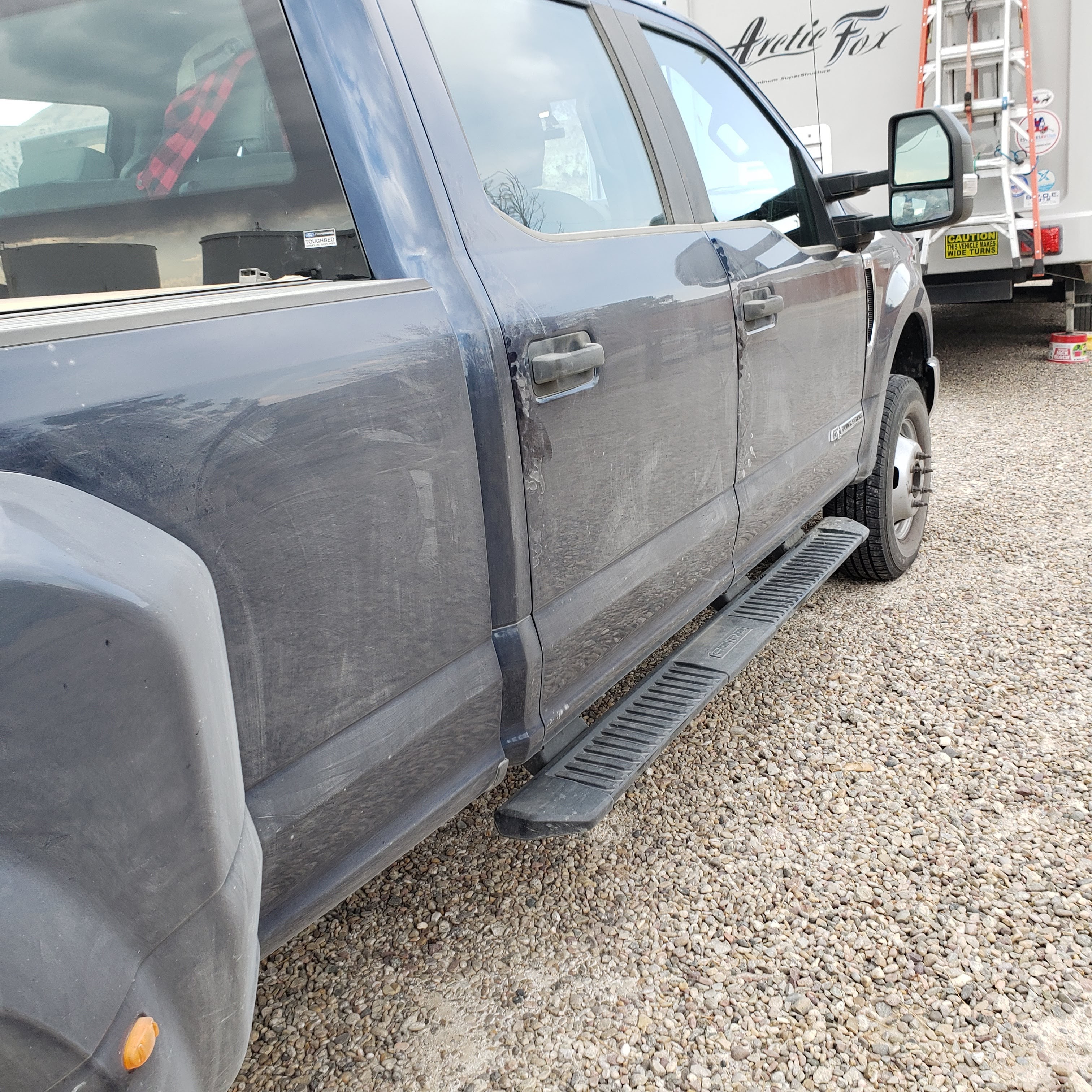
The last few days were windy and a some rain. The first day the wind was steady at 15 mph, gusting to 30+ mph and a couple of hours of rain. Remember the day before we went off-roading... well the rain came directionally at a steady pace. The result of the steady directional rain was a fairly clean truck... on one side, the other side was still dirty. The weather had cooled down by 20 degrees, and that made a difference. The campground is at an elevation of about 6,200 feet. With that said, what comes with rain at a higher altitude? Yes we did get some snow around us in the higher altitudes, but not in the campground itself.
The next day winds increased to steady 25 mph, gusting anywhere between 45 to 55 mph... so we just hung on till the wind died down. In the meantime we are prepping for our journey into Utah.


No comments:
Post a Comment