While we were at our last campground, the one we won't be going back to anytime soon, we took a drive to what was to be our next stop in the Sturgeon Bay journey. It was a good decision, because it was not going to work for a week stay. The site we were to be at was dry camping (no water, electricity, or sewer), and very shaded. Without solar we would struggle with electricity... and generators were not allowed.
Here we now move to plan "B". We drove to the campground that was two later in our journey and asked if they was an opening for us to arrive a week earlier, the answer was yes. Accepting the additional week meant that we would start in one site, and move to a second site, which was our original reservation.
We arrived at our new home, and beat the rain by a day.
For a couple of days it decided we needed a bit of rain, and for the folks that are local to the area, it was an answer to their drought prayer. Once the rain settles down we can take a drive through some of the little towns around here, and see some of the attractions. Door County has a lot of touristy stuff to see and do. I'm sure you have been watching the news regarding the Canadian wildfires, and the smoke crossing into the U.S. (I bet without a passport). For those living in California, the smoke they are getting here might not seem like much, but it has been fairly thick in some areas.
I promised more lighthouses, but before we see another one, we are going to take you to a motorcycle memorial park.
The park was designed to be a fun, and a happy remembrance of their fallen friends.
Traveling the back roads of the United States, one can find fantastic secret spots off the beaten path.
Enough daydreamin', lets get on down that road. We took a drive towards Washington Island so we could find out what was needed to get on the ferry and tour the island. On the way we found another maritime museum, Death's Door. (https://dcmm.wpengine.com/deaths-door-maritime-museum)
This museum is dedicated to commercial fishing and the shipping fleet.The yellow dots represents the ships that got too close to shore and sank. Zooming in on the photo you will see that some of the dots list several ships going down within the area of the dot. Most of the incidents occurred due to weather conditions unfavorable to sailing. These dots only represent a fraction of the more than 200 documented shipwrecks.
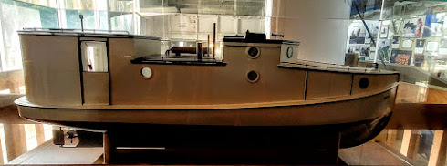
In the early 20th century these boats were known as "fish tugs". It was fun going on the HOPE, and trust me when I say TALL PEOPLE BEWARE. Carol and I are both shorter than 6 feet tall, and we needed to duck getting to the helm station. The last photo is the "net winch" or "net hauler". They would haul in the nets, and separate fish from net, each going in their own compartments. Once on shore, the nets were hung to dry , and the fish were sent to the processing facility. The little guy saw its last haul of fish in 1992.


No comments:
Post a Comment