Here is a little thought I had when we were at the transportation museum and I saw this sign:

I asked the docent with us a simple question: "do you rotate your politicians?", he wouldn't answer.
I thought the sign should look like this:

The sign actually pertained to a piece of equipment:

This wagon was used to spread cow manure on a dairy farm in the early 1900s.
We made our oh, so long drive to our next stop in Stockton Springs. This was one of those "test your stamina" drives, maxing out at 46 miles. We did make it though. We crossed a bridge and could not see what was around us except for the four lanes of the bridge, this was because of the fog. It was encountered the last five miles of our drive.
This stop was a quaint little park with about 20 sites, close to the bay. If the photos look a little off, blame it on the fog.


I think the word "resort" is incorrectly used sometimes, and this is one of those times. It is a nice and quiet park, but nothing special. I just had an epiphany about "resort". Different regions define "resort" in different terms.


This is what you are looking at in the four-photo array, in the bottom left photo. These pilings are remains of the Waldo-Hancock Bridge.

The left photo was 2007, right side was 2013. There is no toll to cross the Penobscot Narrows Bridge today.

This was our next stop in the state park. The fort had an interesting story to tell. This fort was part of the "Third System" of national coastal defense forts. What made the Third System unique from the other two systems, it was guided by a professional board of engineers in the War Department, and not during time of war.
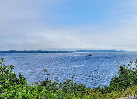
The first night here we decided to drive to the marina down the hill from the campground, and had dinner. We were told that it had nice views, but the fog, yes I said fog, might be hiding them.


We are always looking to experience regional drinks, no different here. Carol had a cocktail they made for the 4th of July, called "Lemon Ginger Bang". Being the ginger lover she is, she asked for more ginger. The cocktail was very good. Me being the hardy drinker I am, I had mine straight from the bottle: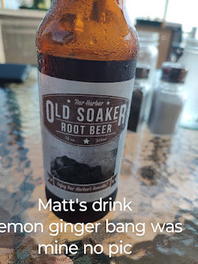

Left is a blackberry tart, with crust only on the top, middle was a flourless chocolate torte, and on the right was a raspberry mousse.
After dinner we headed home to plan our next day's adventure,


WE ARRIVED FOR DINNER

LESS THAN AN HOUR AFTER WE SAT DOWN.
I stopped showing you what we have to eat, but today I will make an exception... again. Carol kept her meal simple for the main course:
I myself went a bit more extravagant, I had baked haddock w/rice, and haddock chowder: I added the rice to my chowder.

LOBSTER STUFFED MUSHROOMS

We are always looking to experience regional drinks, no different here. Carol had a cocktail they made for the 4th of July, called "Lemon Ginger Bang". Being the ginger lover she is, she asked for more ginger. The cocktail was very good. Me being the hardy drinker I am, I had mine straight from the bottle:

A ROOT BEER OUT OF MAINE
Did we for go dessert... not a chance. Carol went for a sampler plate and I went for the bourbon pecan bread pudding.

What's warm bread pudding without ice cream.

When we checked in the owner/operator told us about some local places to go see on the island that are close to the campground, and here is one of them.


 This marker represents the burial spot for a General Samuel Waldo. He must have been of some importance as the county is named after him.

FORT POINTE LIGHTHOUSE

BELL TOWER OIL HOUSE
This bell tower, built around 1890, is one of a few left in the United States. These bell towers were used as fog signals.
The iron weights were suspended at the top of the wooden chimney, and were connected to the Stevens Fog Bell Apparatus (SFBA) via a wire cable. The SFBA was connected to the striking hammer. The geared SFBA would cause the hammer to strike the bell every 20 seconds. Here is where the lighthouse keeper comes in, he had to wind the Stevens Fog Bell Apparatus every four hours.

In 1958 the Stevens Fog Bell Apparatus was replaced with a hammer that was on a cam, and driven by an electric motor. In 1960s the bell was replaced with an electric diaphragm horn. Still later, the horn was relocated outside the light tower, and eventually relocated on the cliff, all the keepers needed to do was flip a switch when the fog rolled in. In the 1980s, the fog horn was again updated, this time when a videograph B was installed. The videograph B was an automatic fog detection device, and would turn on at the first indication of fog. If interested, look up videograph B online.
The Oil House is similar to others I have posted, this one was built in 1897. Whale oil was delivered once a year to the lighthouse, and stored in two 90 gallons barrels. Later on the Lighthouse Service switched to kerosene because it was less expensive. Another advantage to kerosene, it burned brighter. This house did well until 1952, when the lighthouse received electricity. Today it uses a 250 watt halogen bulb and Fresnel lens, shining light 10 miles up the Penobscot River.


This state park is also home to the ruins of Fort Pownall.


The fort was constructed in 1759. at the suggestion of Massachusetts Governor Thomas Pownall in 1758. His goal was to block up Maine's riverways, keeping the Indians and French land locked. He figured that putting a fort in this area would drive off the remaining Indians from their hunting and fishing area, allowing the English to create a port to conduct business from. The governor and 400 men came here and built the fort.


The fort was constructed in 1759. at the suggestion of Massachusetts Governor Thomas Pownall in 1758. His goal was to block up Maine's riverways, keeping the Indians and French land locked. He figured that putting a fort in this area would drive off the remaining Indians from their hunting and fishing area, allowing the English to create a port to conduct business from. The governor and 400 men came here and built the fort.

The fort never fire a shot, but its presence encouraged Anglo-American settlements to develop in the region. In 1775 the British took all their cannons, for good reason, there was a rebellion brewing in the "United States". Later the continentals burned the blockhouse, and filled in the ditches so the Brits couldn't re-occupy the fort.

You may be saying to yourself, I now know where Waldo is, and I would politely tell you...WRONG. At some point, probably the late 1700s or early 1800s, his body was moved to the Kings Chapel in Boston. Now you know where Waldo is.
All this adventure cost us was $2.00 because we are seniors, if we were residents it would have been free. This adventure has concluded, so we headed home for dinner.
Another day we took a drive back to the Penobscot Bridge and Fort Knox. It was amazing to see what was around the bridge when there was no fog.
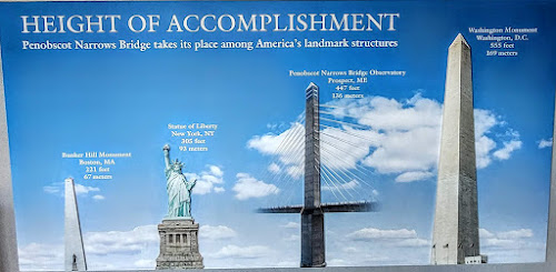
Bunker hill Monument is 221 feet, Statue of Liberty is 305 feet, Penobscot Narrows Bridge is 447 feet, and the Washington Monument is 555 feet. Going up the elevator has no view, its in the middle of the tower, and actually stops two floors below the observation deck.
Another day we took a drive back to the Penobscot Bridge and Fort Knox. It was amazing to see what was around the bridge when there was no fog.
First stop was the usual, pay booth, then to the bridge so we could ride the elevator up to the observation deck. 
We were headed to the top, which was the observation deck providing a 360° view of the Penobscot region.

We were headed to the top, which was the observation deck providing a 360° view of the Penobscot region.
Smile second: how many of you are thinking of M.A.S.H. and "Hot Lips" Houlihan, and her marriage to Major Penobscot? That is where my mind travels when I here this name.
Back to seriousness.
Let us put the bridge in perspective as far as size:

OBSERVATION DECK ON 3RD FLOOR
We made it to the last, and only stop for the elevator. We got out of the elevator and fortunately they have a handicap lift so Carol could get to the observation deck, otherwise it was climbing four sets of stairs. The climb was worth it.
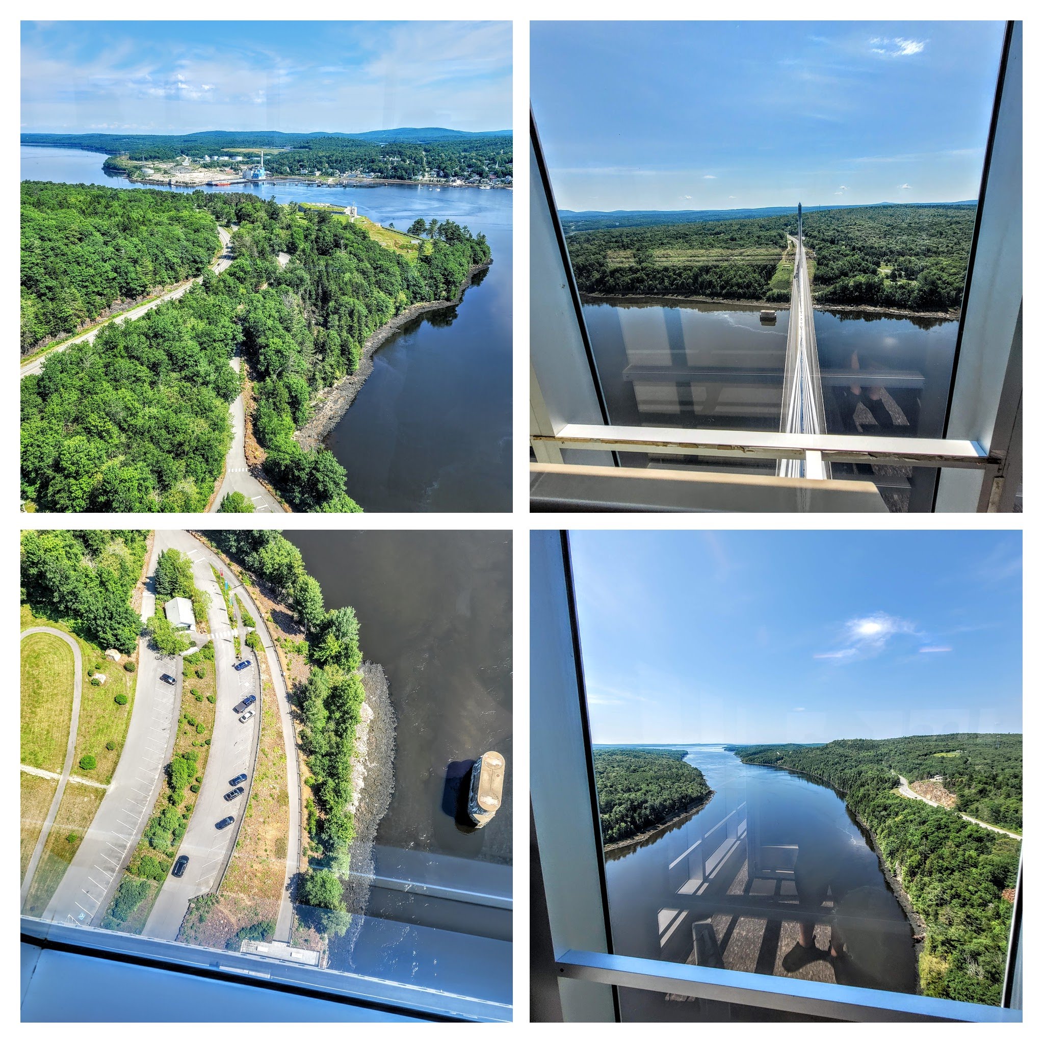

This is what you are looking at in the four-photo array, in the bottom left photo. These pilings are remains of the Waldo-Hancock Bridge.
So, why was the Waldo-Hancock Bridge built in the first place? Back in the early days of the automobile, drivers had two options for crossing the Penobscot River, wait in long lines for the ferry, or a drive 27 miles north and cross between Bangor and Brewer.
In 1929, the Maine voters said yes to funding the creation of the Waldo-Hancock Bridge, and in November of 1931, the bridge was open to traffic. How excited were drivers when the bridge was completed... 2500 cars paid the toll to get across the bridge... and this was the first week.
So how did the bridge come about its name... easy, it connects the two counties on each side of the bridge.

For its time, this was a spectacular bridge in Maine. The overall length of the bridge was 2,040 feet, the main span was 800 feet, which made it the longest span in Maine.
The burning question... why did they replace the bridge... excessive corrosion in the cables. In 2003 when the corrosion was discovered, it was decided that a new bridge was needed. The engineers made two decision, one was to lower the load limit of 100,000 pounds, to 24,000 pounds. Second, they had 16 new strengthening cable fabricated and installed while the new bridge was being built.

WALDO-HANCOCK BRIDGE
(Photo courtesy of Centpacrr at English Wikipedia; ca 2006)

(Photo courtesy of Jet Lowe)

(Photo courtesy of Centpacrr at English Wikipedia)
The left photo was 2007, right side was 2013. There is no toll to cross the Penobscot Narrows Bridge today.

FORT KNOX
This was our next stop in the state park. The fort had an interesting story to tell. This fort was part of the "Third System" of national coastal defense forts. What made the Third System unique from the other two systems, it was guided by a professional board of engineers in the War Department, and not during time of war.
25 years was spent building this fort, and it was never finished, but was used during construction. Part of what made these third system forts spectacular were the cannon casements.


Besides the cannons in the fort, they had two outside batteries too. The inside cannon casements are a mirror image, and the outside batteries at opposite ends of the fort.


These batteries were the only fully complete parts of the fort when the first regiments moved in. There were no cannons on the batteries because they were built for one style of cannon, and the War Department moved up to a newer model cannon.
Here is an example of a structure for the first intended cannon:


HOT SHOT FURNACE

FRONT BACK
The cannon ball was fed in at the front, roll towards the back, all the while being heated up before loading the ball in the cannon. 
The purpose of heating the balls was to cause a fire on the enemy ship passing through the channel. Intended for wood ships.
The furnace was never used though, the newer model cannon used a different, and heavier cannon ball that inflicted other serious damage to an enemy ship. Intended for iron clads.
Another way of protecting the riverway was by use of the "Buoyant Submarine Torpedo". This was not to destroy submarines, but damage iron clad ships. 
These mines were filled with 100 pounds of dynamite, anchored in the river, and electrically set off from the fort. These mines did cause some issues with regular shipping business, so some of the mines were removed to create a shipping lane.
Now that we have looked at protecting outside the fort, we can go inside and see how they dealt with protecting the fort from land attack.
This was accomplished by digging a dry moat (ditch) that ground troops would have to cross to get to the fort, and adding shooting ports in the walls on each side of the moat.
The top photo is looking up to the top of the ditch, lower photos are the shooting ports. The two pictured here are from looking opposite ways in the passages.

The top photo is looking up to the top of the ditch, lower photos are the shooting ports. The two pictured here are from looking opposite ways in the passages.
This fort when completed would have housed the officers and enlisted in their respective quarters. 
Since the fort was never completed, the enlisted soldiers had to sleep outside the fort, while the officers enjoyed their quarters inside the fort.

Since the fort was never completed, the enlisted soldiers had to sleep outside the fort, while the officers enjoyed their quarters inside the fort.
The main structure was also to include a bakery: UPPER LEFT: DOUGH BIN

UPER RIGHT: DRYING ROOM
LOWER LEFT: KNEADING TABLE
LOWER RIGHT: BAKING OVENS
Off the bakery was the enlisted mess for daily meals. The officers were in a different area of the compound.


OFFICERS QUARTERS AND MESS HALL

ENLISTED MESS HALL

Out that door would have led to the enlisted barrack; there were two such doors. The window/door area would have been the washroom. The end that I am standing at would have been some type of quarters. Looking down the hall is more of these rooms, but they were without doors to the un-built barracks. The last room was their cistern room (for holding water):

This was between the wing for the enlisted, and the wing for the officers.
The fort's storerooms for the bakery and kitchen would have been located under the enlisted barracks.

STAIRS TO STOREROOMS / STOREROOM
The doors that allowed passage to the barracks would have passed over theses storerooms.
The construction of this fort started way before the Civil War, and still was not completed after the Civil War. I mention the Civil War only because raiders from the South actually made into this area, causing the fort to require manning.
So there you go, a fort that was never completed, and never fired a shot.
Visit: https://www.fortknoxmaine.com
There are a lot of cemeteries around this place, but I believe this is the first one that I've seen where the residents can still get mail:
Here comes a bad pun...

Here comes a bad pun...

... a view worth dying for. These cemeteries are old, and no longer appear to be active cemeteries. Because this area was big in the shipping industry, there are a lot of sea captains and their families buried here, and many of their relatives still live in the area.
On another day when Carol's foot was bothering her, I took a drive to the Penobscot Marine Museum in Searsport.
This museum is set up throughout multiple buildings, containing information and exhibits of all kinds, from the world of a lobster to artwork by local residents.

I am going to start off in the Men's Restroom.

This lobster was caught here in Maine in 1922. The largest recorded lobster weighed in over 44 pounds. While I am talking lobsters first, let's ask a few questions.
Q1: Are lobsters right or left clawed?
A: The bigger claw is called the "crusher" claw, used to break open mussels and clams. The longer claw is called the "pincher" or "seizer" or "ripper" claw. The hardness is based on the larger crusher claw, determining right or left. Adolescent lobsters have a 50/50 shot at being "right" or "left" clawed.
FUN FACT: If a lobster gets in a fight, and loses a claw, they can grow it back, providing they survive to confrontation.
Q2: What does a lobster eat?
A: Almost anything they want, mostly clams, mussels, crabs, worms, an occasional sea urchin, and they may even eat plants. They have been known to be cannibals, eating each other, if confined too long.
Q3: Who eat lobsters?
A: Besides humans, many fish, like the Wolffish, Cod, Flounder, eels, green crabs, and seals.
Q4: How do lobster see?
A: Not well, only light and dark, and shapes. Their exception ability is smelling. They can distinguish individual lobsters and source food.
FUN FACT: They smell in color.
Q5: How does a lobster get bigger?
A: Between larval stage and adult, they will shed their shell 25 times. Once an adult, they generally shed once a year.
Carol and I learned how to tell if a lobster had recently shed. A lobster that recently shed has a softer shell, which is a bit "giving" when trying to crack it. The ones that hadn't shed were a much harder shell, and tougher to crack. Here are examples:


Fowler was the original builder/owner, a farmer and schooner captain, sold to his relative (True), then to Ross, the wife of True's nephew. In 1967 the museum acquired the home.
Inside the room that was general viewing, it talked about the life of a sailor.
 This boat shed housed the exhibit on building a "peapod" boat.
 Step into the workshop. Ahead of you is a finished boat, and one under construction. As we neared the boat under construction, there was detailed information about the jig it was on, and the process for completing the boat construction. They do have periodic demonstrations.
They even have a sign that helps the visitor learn to speak like a real boat builder using words like sheerstrake, keel, and garboard. Most lumber or trees don't grow in the correct bend for the planks necessary to build this boat, so the boat builder will use one of these:

Next stop on the walking tour is a boat barn containing... more boats.


Visitors can stand at the helm of a lobster boat, fish from their own boat, or learn about what is happening to the fishing industry at large. The posterboard at the bottom right was created by one of the high school classes, it talks about the invasion of the green crab, which are not native to this area. The green crab is wreaking havoc on the lobster community, they love to consume larval lobster.

The parcel of land bought by James Merithew was broken into three lots, his home, the lot for the Congregational Church, and this home. He divided his parcel of land after his home was finished.

The vault is still in the building, it is their storeroom.

HAD NOT SHED, HARD TO CRACK

RECENTLY SHED, EASY TO CRACK
Time to venture to the different buildings. Several of the buildings were guided tour only, and I made it to one of them.

THE VESTRY HOUSE ca. 1841

TIN ON CEILING AND WALLS
The first floor housed a story about a local resident that was born at sea, and the child of a sea captain. She later became a well known author in the area.
The home across the street was one of those that was a guided tour, with exception of one room, packed with seafaring information.

FOWLER-TRUE-ROSS HOUSE
Built between 1801-15, with an addition in 1837
Fowler was the original builder/owner, a farmer and schooner captain, sold to his relative (True), then to Ross, the wife of True's nephew. In 1967 the museum acquired the home.
Inside the room that was general viewing, it talked about the life of a sailor.

A schooner, much like what Mr. Fowler would have captained. On the wall by the door was a chart of time keeping... tolling of the bell.

Sailors and Marines riding a ship were very familiar with the tolling of the bell. Every four hours the bell would, and still does today, ring eight times, in pairs of two (ding-ding ding-ding ding-ding ding-ding). If the afternoon watch watchstander heard ding-ding ding-ding, he knew his watch was half over.
Ding-ding ding-ding ding-ding ding-ding (noon, start of the watch).
Ding-ding ding-ding (2:00pm or 1400 military)
Ding-ding ding-ding ding (2:30 pm or 1430 military)
Much like the ships today, there was always some type of maintenance that needed to be accomplished, such as scrubbing the deck, holystoning (sanding the deck), painting, caulking, or maybe sail repair. When they weren't doing maintenance, they were either sleeping or on watch. We will come back to the building later.
The museum is full of demonstrations for the visitor as well, plus they have a lot of interaction with school children through various programs.
An example of the demonstrations is the rigging of sails: It is a demonstration as to how sails are raised and lowered, and talks about how sails are set for the various conditions the ship might encounter.

They had several boat barns and a boat shed displaying a variety of small boats.


They even have a sign that helps the visitor learn to speak like a real boat builder using words like sheerstrake, keel, and garboard. Most lumber or trees don't grow in the correct bend for the planks necessary to build this boat, so the boat builder will use one of these:

BOILING TANK
Other tools of the trade to build a boat include sanders, clamps, more jigs for the small stuff.


SOME OF THE FINISHED BOATS
Next stop on the walking tour is a boat barn containing... more boats.


I'm not sure why this is part of the exhibits, but it was interesting enough for me to check it out.

This box camera was sitting on the lawn for visitors to experience "camera obscura". Entering the camera, visitors close the door for total darkness, with the exception of the lens opening. Visitors are now experiencing how the camera make images on plates... light entering a small opening.
Our next stop was the home of another sea captain and his family.


This to was a piece of the property owned by Miles Fowler. The Merithew's bought the piece of property and built the house in 1826. This particular piece of land was the highest point of the Fowler property, and eventually became the center of the town Searsport Village.


NICKELS-COLCORD-DUNCAN HOUSE (ca. 1841-45)
This house went through several owners. The land it sits on was part of the property Mr. Miles Fowler, remember, he was the farmer sea captain. The core of the house was built between 1841 and 1845. A tailor by the name of Howland Otis bought this piece of property from Mr. Fowler for $300.00, part of an agreement they made back in 1841. In the following months the house was sold several times, in four years the house would be sold again to a physician, for a $1,000.00.
By 1862 a sea captain by the name of James Merithew buys the house and gives it to his daughter Lucy, who then sells it to her husband David Nickels for $10,000.00. After Nickels dies, Lucy sells the house to Captain Colcord, who lived in it for 22 years. The next owner was a land surveyor by the name of Duncan. He lived in the house until his death, his heirs sold the house to the museum in 1960.
Today the house is the administrative offices of the museum.

JAMES MERITHEW HOUSE (ca. 1826)

AS SEEN AROUND 1949
Those brick used to build the house were hauled in from 10 miles away, using oxen. This house sits almost across the street from the one James bought for his daughter.
Mr. Merithew had several business interests in the town, one was a shipyard he founded in 1816, and the local bank he owned.
Speaking of the bank quickly, it was not scared of women's lib, they had pictures of women on their money.
My thought is that he either used his wife or daughter for the pictures.

My thought is that he either used his wife or daughter for the pictures.
Next to the Merithew home was the Congregational Church.
This is an active church today, but allows tours for visitors of the museum, unfortunately I missed the times. As the story is told, the church was started by 11 women and 2 men.


Beautiful stained glass windows that are original to the church. Apparently they have a fantastic pipe organ too.
Across the street from the church was their Town Hall built back in 1845.

TOWN HALL (ca. 1845)
The town hall building came about when Jane Fowler sold a piece of their property to the community in 1843, which was when Searsport separated themselves from the surrounding towns of Prospect and East Belfast.
The story goes that when David Sears, whom the town is named after, was not pleased with the building, left town, never to return. How egos can destroy one's life, so sad.
By 1905 Searsport was using another building as their town hall, and the old Town Hall building became a jail and storge space. In 1936 the building was sold to the museum.
Today the building educates visitors about the fishing industry around the area.

Visitors can stand at the helm of a lobster boat, fish from their own boat, or learn about what is happening to the fishing industry at large. The posterboard at the bottom right was created by one of the high school classes, it talks about the invasion of the green crab, which are not native to this area. The green crab is wreaking havoc on the lobster community, they love to consume larval lobster.
How is wild Atlantic salmon caught?

Net goes from the shore, out into the water, and a circle is at the end. This catching them in the wild, not farmed. The lead salmon will swim in following the netting and circle, all the others follow, and they are trapped. DON'T BUY FARM RAISED SALMON. A lot of the time they are injected with junk, including coloring to give the a pink color.
Time to go visit the Fowler home. Today the home displays items brought back from trips at sea. 

When this house was first built it only had this room and the room visitors could enter without being on the tour. Later on the house was made larger to accommodate their daughter and her husband.
Many of the items in the house are from descendants of the many sea captain families, and have been donated to the museum.
For instance, a visitor was going through this tour some years ago and noticed a broach worn in one of the paintings, and commented that she had seen that broach before. Come to find out, the reason she saw the broach before, she was the owner of it. It was passed down through her family.

Don't mind the ghost behind the painting. The painting broach is the upper right, the original is bottom right.
Here are some of the souvenirs brought back.
Because there was a lot of ships leaving this harbor town, many of the captains came back with similar trinkets, so many items were never on display in the homes because others had them too. I did find one of interest though:

Because there was a lot of ships leaving this harbor town, many of the captains came back with similar trinkets, so many items were never on display in the homes because others had them too. I did find one of interest though:

For those of you that have not seen the real bird of paradise, this is what they look like. Sea captains quite often brought home animals that were taxidermied (stuffed).
As a tight-knit community, ships lost at sea were given respect.

INDICATION OF A SHIP LOST AT SEA
Our last home we visit is now a fun learning center for children.

JOSIAH DUTCH HOUSE (ca. 1848)
The parcel of land bought by James Merithew was broken into three lots, his home, the lot for the Congregational Church, and this home. He divided his parcel of land after his home was finished.
This piece of land he sold to his sons in 1848, and either James or his sons built the house. this house had many different owners in its early days which included, schooner captains, postmaster, and the Searsport town clerk.
Josiah Dutch was a shipwright in Searsport, and lived in the house from 1882 to 1891.
Today:


A CHILDREN'S LEARNING CENTER
I mentioned the James Merithew was the bank owner, well during the Fowler house tour the docent said the bank is now a candy and ice cream shop... a must visit, and I agreed.

The vault is still in the building, it is their storeroom.
I had never tried a Needham until visited this shop, and I tell you what, I would eat another one. Biting into the thick chocolate coating, the mashed potato and coconut filling smiled at me. Today one can find different flavors of this New England treat. I brought home an assortment of truffles for Carol to enjoy.
Time to go home.
No comments:
Post a Comment